The RVRT as a Conservation ConduitAnother one of its Multi-layered Benefits (August 2023) By Terry J. Lewin (RVRT Inc. Vice-President - RVRT Supporters’ Group) Extracted from RVRT Inc. Facebook Post – August 16th 2023: https://www.facebook.com/richmondrailtrail/posts/pfbid026d5v3kweq2PcwDJduPSihbRPHDJCNuUEmWvzZFCDSiHvvvjSacN1u9Q1826cAVsil The 32+ km RVRT will support a broad range of user groups and deliver multi-layered benefits, including:
The RVRT will also be an essential element within the proposed 100+ km broader ‘Shiraz to Shore’ Hunter Cycle Trail [an initiative of the Hunter Joint Organisation of Councils], as well as uniquely linking metropolitan and rural communities and attractions. While the search for RVRT (and ‘Shiraz to Shore’) funding is likely to involve grant applications to multiple targeted schemes addressing individual policy goals (e.g., Regional Growth, Active Transport, Tourism, Socio-Economic Disadvantage, Disaster Recovery), we need to continue to emphasise the trail’s wide-ranging benefits and to promote integrated development that optimises these benefits for local communities and the overall Hunter Region. This particular Post focuses on one of the RVRT’s unique features – its role as a conservation conduit – and the associated challenges and opportunities. Conservation Conduit: As noted in the Review of Environmental Factors (GHD Pty. Ltd., Appendix G, Socio-Economic Impact Assessment, September 2019, Executive Summary, page vii):‘… Establishment of the RVRT will provide a unique conduit for accessing the region’s varied ecosystems, … which will encourage longer-term development of other local walking trails, further social/recreational infrastructure investment, and associated educational and environmental programs. It will also stimulate long-term development of related recreational, educational and environmental programs’. The critical aspect of this conservation conduit is that ‘… the RVRT passes through or nearby to several high conservation value areas that have previously been largely inaccessible to the general public’, including coastal wetlands, national parks and reserves. 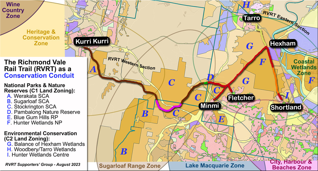 Image 1. This graphic highlights the State Conservation Areas (SCAs), National (NP) and Regional (RP) Parks, Nature Reserves and Wetlands Areas that are either adjacent to the RVRT or through which it travels. Some of the Suggested Strategic Zones (or Themes) have also been added, which could be used to characterise and publicise broad segments within the RVRT (and the ‘Shiraz to Shore’ trail). [The base Land Zoning Map was obtained via the NSW Planning Portal Spatial Viewer, NSW Department of Planning and Environment]. 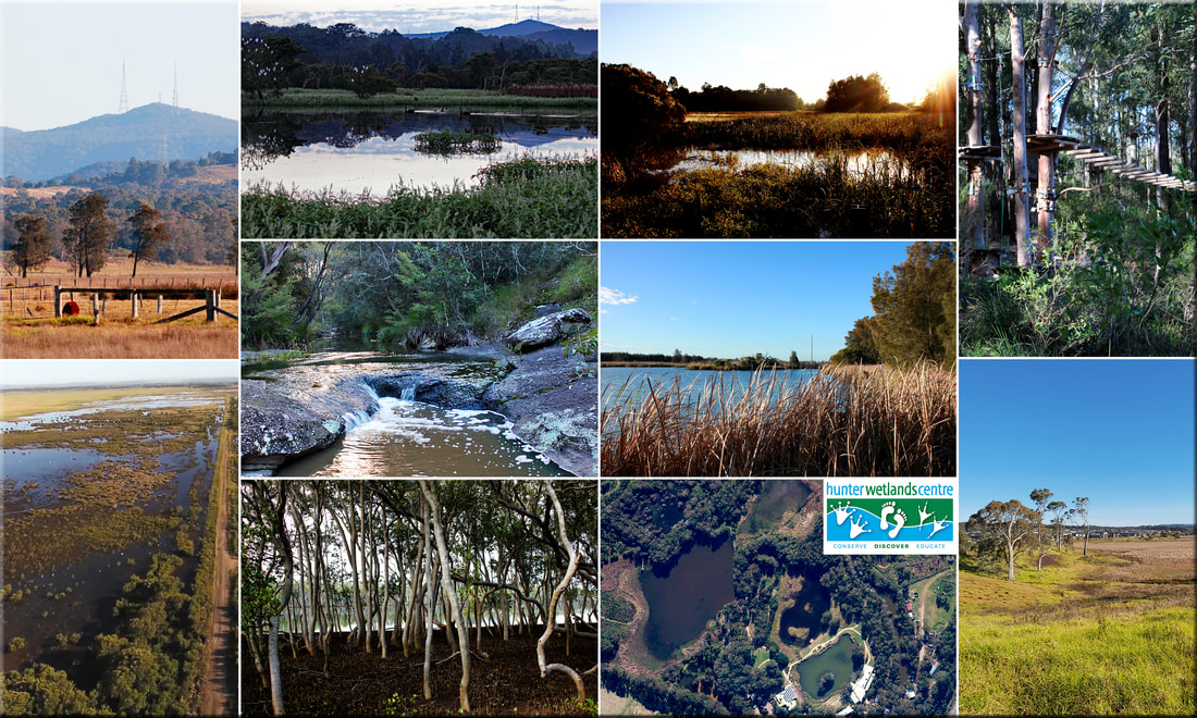 Image 2. This ten-photo montage illustrates some of the high conservation value areas surrounding the RVRT – (From top left) 1: Mount Sugarloaf from Hexham Wetlands; 2 & 3: Pambalong Nature Reserve; 4: Treetops Adventure, Blue Gum Hills RP; 5: Blue Gum Creek, Stockrington SCA; 6: Tarro Wetlands; 7: Aerial view of Western Section of Hunter Wetlands NP (from TFI’s 2017 video); 8: Mangroves in Hunter Wetlands NP; 9: Aerial view of Hunter Wetlands Centre, Shortland; and 10: Wetlands near Fletcher RVRT hub. Challenges and Opportunities: As the majority of the RVRT runs through or adjacent to NSW National Parks and Wildlife Service (NPWS) managed lands, care needs to be taken to ensure that their day-to-day operations and conservation and seasonal activities are not negatively impacted. RVRT related grant applications will probably also need to include some funding to protect NPWS assets and functions – in exactly the same way that mitigation measures are identified/negotiated with any other landowners. Moreover, some of the newer conservation areas (e.g., Stockrington and Werakata SCAs) have a range of locations that should become destinations in their own right, with appropriate nurturing and funding (e.g., the ‘mid-trail precinct’ at Stockrington). Some other potential (future) opportunities are also starting to emerge. For example, it may be possible to use another former pipeline corridor (between Shortland and Wallsend/Maryland) to create an RVRT ‘Coastal Wetlands’ shared pathways loop via Fletcher, Minmi & Hexham Junctions. Similarly, with respect to the ‘Shiraz to Shore’, it may be possible to link Abermain and Nulkaba via gravel paths running through Werakata NP, which would facilitate development of another conservation-rich Cessnock/Hunter Valley Loop – via Bridges Hill Park (Cessnock), Nulkaba, Abermain, and Neath. Thanks to all of our RVRT supporters! CONSTRUCTIVE COMMENTS AND FEEDBACK WELCOME.
0 Comments
Leave a Reply. |
News Archive
|
 RSS Feed
