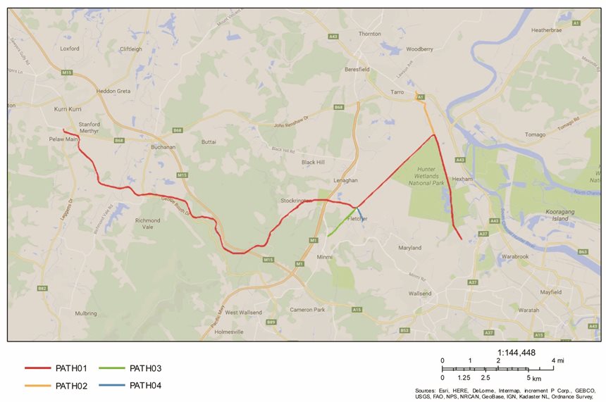
Speers Point (Lake Macquarie) to the Richmond Vale Rail Trail (RVRT) – Building on Existing and Proposed Shared Pathways Extracted from RVRT Inc. Facebook Post – June 12th 2023: https://www.facebook.com/richmondrailtrail/posts/pfbid0AD6Vn5EvSQ7UoZWBMhio44ePrhRQ9wpdpesSqUeZeNFNGusijHiz3zaH2G9bGeyfl As we move towards finalising initial approvals along the RVRT route, it is essential that we continue to simultaneously develop and upgrade local shared pathways and community connections. There are three proposed south-eastern RVRT Local Hubs within Newcastle LGA, at Shortland, Fletcher and Minmi. As detailed in an earlier Post, the City of Newcastle is currently exploring potential active transport improvements within Shortland and Tarro (at both ends of that section of the RVRT) – Link to “Have Your Say” (by June 26th 2023): https://haveyoursay.newcastle.nsw.gov.au/shortland-and-tarro-cycleway Initially, the RVRT connection through the Fletcher Hub is likely to become the main route that Newcastle and Lake Macquarie residents and visitors use to access the western section of the RVRT [or vice versa for Cessnock and Kurri Kurri residents and visitors travelling eastward]. As shown in Image 1 below, the Fletcher Hub is also likely to provide an essential connection point for the proposed broader ‘Shiraz to Shore’ Hunter Cycle Trail, an initiative of the Hunter Joint Organisation of Councils (Hunter JO). [The RVRT and Hunter Cycle Trail are both identified as priority projects within the Hunter Regional Plan 2041 (Dec. 2022)]. 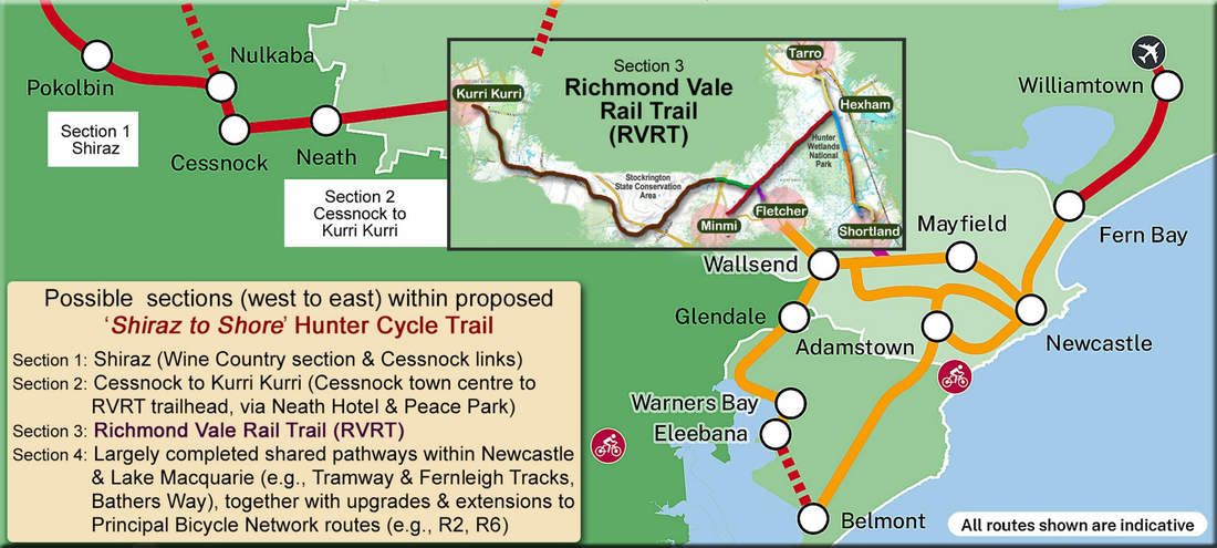 Image 1: The RVRT is an essential element within the proposed broader ‘Shiraz to Shore’ Hunter Cycle Trail [an initiative of the Hunter Joint Organisation of Councils]. This image includes a more detailed RVRT Insert (and illustrative RVRT Local Hubs). Although other future connections from Lake Macquarie LGA to the RVRT will also need to be developed (e.g., via the proposed R2 Principal Bicycle Network route through Edgeworth, Cameron Park and Minmi – see Image 2), we are in the fortunate position of having two existing inter-connected, high-quality off-road shared pathways: the 4.6 km Speers Point to Glendale Shared Pathway (opened in February 2022); and the 3.9 km Tramway Track (or Wallsend to Glendale Shared Pathway, opened in June 2012). [Steam trams transported passengers along this route from Newcastle and West Wallsend to Speers Point Park from 1912 – 1932]. 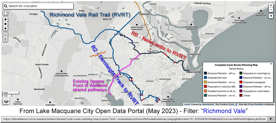 Image 2: Likely future connections to the RVRT via Principal Bicycle Network routes (R2 and R6) and existing Speers Point to Wallsend Shared Pathways. Image 3 illustrates the existing off-road Shared Pathway connections between Speers Point and Glendale (Lake Macquarie LGA, see right-hand image) and between Glendale and Wallsend (Newcastle LGA, see left-hand image). The Tramway Track ends at Ganney Road Wallsend, but there are a mix of shared paths and bike friendly roadways that enable onward connection to the R6 (near the intersection of Cowper Street and Minmi Road) and then onto the University of Newcastle. The R6 is likely to become the main connector between Newcastle LGA and the RVRT, facilitating connections through both Shortland and Wallsend/Fletcher (see Image 2). 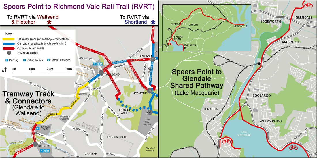 Image 3: Off-road western Shared Pathway links between Newcastle and Lake Macquarie LGAs - Speers Point to Glendale Shared Pathway (right-hand image); and Tramway Track [or Wallsend to Glendale Shared Pathway] (left-hand image). Future connections to the RVRT at Wallsend/Fletcher and Shortland are indicated by asterisks (top-left of image). Map links are provided in the body of the Post. Note - this image only focuses on a small section of the existing pathways (e.g., Lake Macquarie now has over 120 km of Shared Pathways). Images 4 to 6 present 30 photos taken along the Speers Point to Wallsend Shared Pathways on Tuesday 6th June 2023. 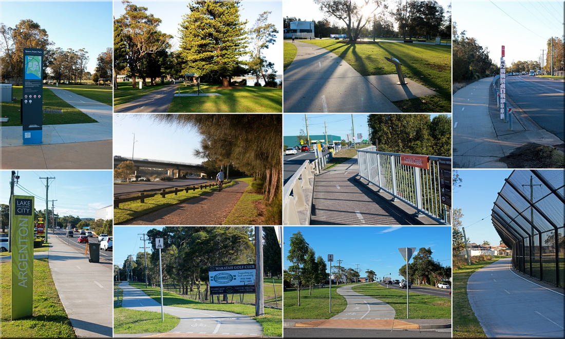 Image 4: Speers Point end of the Shared Pathway – From Speers Point Park, via Creek Reserve Road (alongside Cockle Creek), then adjacent to Lake Road (passed Cockle Creek Station, Argenton, and the southern end of Waratah Golf Club), followed by a 550 m fenced section adjacent to the northern section of the Golf Course, leading to Fredrick Street, Glendale. 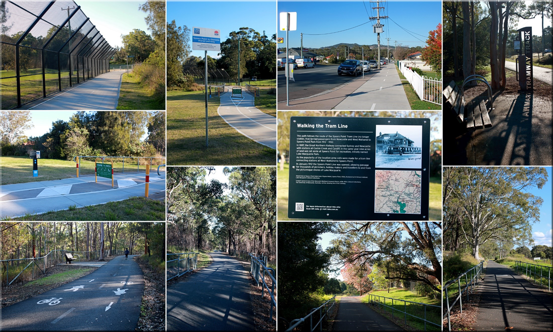 Image 5: Middle Section of the Shared Pathway – From Fredrick Street, passed the Glendale TAFE, and along the Tramway Track – Includes a brief description of the former Tram Line. 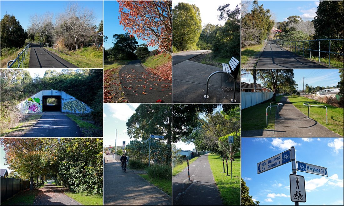 Image 6: Wallsend end of the Shared Pathway – Continuing along the Tramway Track, through the culvert under the Newcastle Link Road, then from Ganney Road to the Wallsend Shopping Centre, and up the slight hill to the cycleway’s sign at the Cowper Street and Minmi Road intersection. Essentially – to optimise future community connections with the RVRT (and the Hunter Cycle Trail), we now need to establish and upgrade shared pathways between the Cowper Street and Minmi Road intersection (Wallsend) and the Fletcher Hub (Kural Crescent, Fletcher), as well as developing workable connections between the University and the Shortland Hub (to facilitate active transport connections between Tarro/Beresfield and the Newcastle Cycleways Network). Link to Download Tramway Track (Wallsend to Glendale Shared Pathway) Map: https://newcastle.nsw.gov.au/Newcastle/media/Documents/Tramway_Track_Map.pdf See Image 7 for updated information about connectors to the Tramway Track. Link to Download Cycling Lake Mac Fold-out Map: https://www.lakemac.com.au/files/assets/public/for-residents/lmc-cycling-map_web.pdf 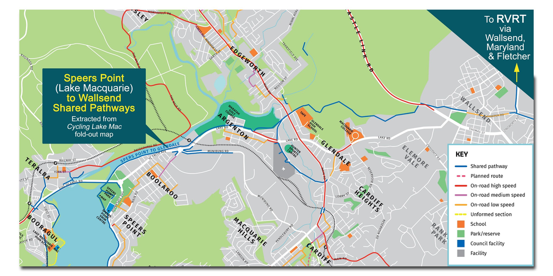 Image 7: Speers Point to Wallsend Shared Pathways – Updated connector information extracted from the Cycling Lake Mac Fold-out Map (Nov. 2022).
0 Comments
Leave a Reply. |
News Archive
|
 RSS Feed