RVRT Newsletter June 2024Contents
General Information and Update
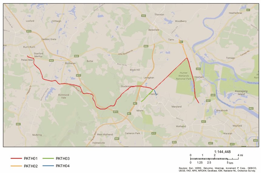
The Richmond Vale Rail Trail (RVRT) will be a regionally significant 32+ km off-road cycling and walking trail from Shortland (near Hunter Wetlands Centre) to Kurri Kurri (Log of Knowledge Park) via Hexham/Tarro and Fletcher/Minmi - see Newsletter image above. The RVRT will run primarily along the former Richmond Vale railway (a private line that closed in 1987), as well as utilising Hunter Water Corporation pipeline corridors within Newcastle LGA.
Download Content
Engaging with Agencies and Elected Representatives

Planning-related RVRT Visit/Walk by Local MPs and Councillors (29/9/2023)
In September 2023, we contributed to a well-organized and highly successful walk through Stockrington State Conservation Area to Tunnel #1 and the nearby railway cutting (see Walking Path image above) – which was designed to further familiarise our elected representatives with the sorts of experiences trail users are likely to have, and to assist them to better understand and promote the RVRT/Shiraz to Shore. Thanks (again) to the 18 attendees, which included: four elected representatives [Meryl Swanson (Federal MP for Paterson); Dan Repacholi (Federal MP for Hunter); and Mayor Jay Suvaal and Cr. Rosa Grine from Cessnock City Council]; three senior representatives from Hunter Joint Organisation of Councils (Hunter JO); four NPWS Officers; six RVRT Supporters’ Group Committee Members; and Belinda McNab (from the Office of Meryl Swanson), who helped to co-ordinate the event (and took most of the photos). 
RVRT Ministerial Visit (23/11/2023)
In November 2023, another opportunity arose for a brief RVRT visit by two Federal MPs – Kristy McBain (MP for Eden-Monaro, and the Federal Minister for Regional Development, Territories and Local Government) and Meryl Swanson (MP for Paterson). To highlight the ‘Coastal Wetlands Zone’ segment of the RVRT (and Shiraz to Shore) we met at Kau-Ma Park, Fletcher. [‘Kau-ma’, meaning ‘To Gather Together’] Kau-Ma Park is an inspirational location, with multiple ‘artworks’ (e.g., Eagle Shelter, Three Canoes, Three Chairs) and fantastic views across Hexham Wetlands and the nearby Rocky Knob outcrop (identified as an ‘Aboriginal Place’ NSW Heritage location). We thank both MPs for their enthusiastic visit and their acknowledgement of the substantial amount of trail planning that has already been undertaken. 
We would also like to take this opportunity to acknowledge and thank Bill Landenberger, a local geologist and keen panorama photographer, who has taken interesting photos along many sections of the trail and the surrounding areas. Link to 360 Cities account:
https://www.360cities.net/en/profile/landy42 
Above: ‘Little Planet’ View of Kau-Ma Park, Fletcher - extracted from Drone Panorama (Bill Landenberger, 18/11/2023, relative altitude of 23 metres).
RVRT Eastern Section – Newcastle LGA
R1: Fletcher to Minmi Junction (approx. 800m, above pipeline, including boardwalk); R2: Minmi (opposite Fire Station) to Minmi Junction (approx. 2km); R3: Pambalong Nature Reserve (Newcastle LGA boundary) to Minmi Junction (approx. 2.2km); R4: Minmi Junction to Hexham Junction (approx. 5.2km); R5: Hexham Junction to Tarro (approx. 2.1km to the link with M1 Extension under construction); and R6: Hexham Junction to Shortland (approx. 5.4km, to near Hunter Wetlands Centre).

Optimising the Tarro-Beresfield Connections:
Construction of the M1 Pacific Motorway Extension to Raymond Terrace is well underway and the finalised Design and Landscape Plan has just been released (May 2024). In the Tarro area, cycle paths from the RVRT will go under the viaduct and up the sides of the M1 Extension embankments (near centre, upper third of image opposite) - allowing experienced riders from the Maitland and Raymond Terrace areas to use the RVRT as an active transport route to Newcastle. Now would also be the perfect time to sort out and construct a new Shared Pathway Bridge over the New England Highway (similar to the Jesmond Shared Pathway Bridge) – allowing all potential RVRT user groups to safely & easily move between the Tarro-Beresfield community and the RVRT (via an Anderson Drive connection). 
RVRT Western Section – Cessnock & Lake Macquarie LGAs
Some further images from the Planning-related Walk/Visit to the RVRT Western Section in September 2023. We thank NPWS for their strong support for this event, as this State Conservation Area is closed.
RVRT Western Section Video (17+ km within Cessnock & Lake Macquarie LGAs) - illustrating Likely Points of Interest (July 2023 YouTube Video, 4 Min. 41 Sec.).

‘Shiraz to Shore’ Trail Proposal by Hunter JO is Gathering Pace
The proposed broader 100+ km Shiraz to Shore Trail extends from Hunter Valley Wine Country to the port of Newcastle and the shores of Lake Macquarie on the Pacific Coast. Hunter Joint Organisation of Councils (Hunter JO) is co-ordinating this proposal, with approx. 20 km of the RVRT (from Kurri Kurri to Fletcher) contributing to core sections of the Shiraz to Shore – see Stylised Map below.

Congratulations to Hunter JO (and Kim Carland & Tim Askew in particular) and the participating Councils and numerous stakeholder groups for their ongoing efforts developing and refining this Proposal. An official public release of Proposal details will occur soon (including the overall Concept Plan & Business Case, and broader Hunter Cycle Tourism Strategy), in conjunction with associated promotional events and materials (https://www.hunterjo.com.au/ ).
The proposed Trail (and RVRT) will simultaneously promote the region as a major cycling tourism destination and directly benefit local communities, families and businesses, including: economic and tourism benefits and diversification; community access and connection; health, lifestyle and liveability benefits; environmental, cultural and heritage appreciation; as well as cycling-specific safety and commuting benefits. The Trail will be free to use, link metropolitan and rural communities and attractions, and provide a unique conservation conduit for accessing coastal wetlands, national parks and reserves. Ensuring other local shared pathways are carefully designed and inter-connected will also contribute to increased patronage and optimising the Trail’s longer-term benefits and sustainability.
Congratulations and Thanks to Billy Metcalf
At our recent (RVRT Inc.) RVRT Supporters’ Group AGM (April 30th 2024) Billy Metcalf stepped down from his official role as President, after many years of dedicated and enthusiastic service.
It is difficult to say precisely when the RVRT Supporter’s Group began. An informal group of cyclists got together in the late 1990s to explore the possibility of transforming the former Richmond Vale Railway corridor into a cycleway. Over time, several inter-related groups within the Hunter also contributed ideas and energy – including: Local Councils, Newcastle Cycleways Movement (NCM), Local cycling groups (e.g., Kurri Kurri Mongrels mountain bike group), Rio Tinto (RTA), Tom Farrell Institute for the Environment (TFI), Donaldson Conservation Trust (DCT), and the National Parks and Wildlife Service (NPWS). RVRT Inc. was registered as a Not-for-Profit Association in August 2015.
Billy Metcalf was the Group’s sole President up until the recent AGM and he will continue to make an active contribution as a Committee Member. Once again, thanks and well done Billy! Local Landcare and Other Initiatives
During the last 12 months, our RVRT/ NPWS Landcare Volunteers worked in a potential future picnic area between Stockrington Road and Blue Gum Creek, within Stockrington State Conservation Area. Thanks to everyone involved – with special thanks to Sam Mansfield and Leigh Gibbens for co-ordinating these activities. Our Landcare Group is currently having a temporary hiatus, with plans to review and resume on ground activities later this year.

Last year we sought to characterise broad segments within the RVRT and Shiraz to Shore as Strategic Zones – with three overlapping zones identified for the RVRT: Coastal Wetlands Zone; Sugarloaf Range Zone; and Heritage & Conservation Zone.
In January 2024, Newcastle Herald ran an excellent (and highly relevant) 7 Part series of articles about Hexham Wetland, to which we made a modest contribution. These articles are accessible from our webpage: Blog-Post Link1 and Blog-Post Link2. 
F.A.S.T. Nearing Completion: Congratulations to Lake Macquarie City Council on the construction of the Fernleigh Awabakal Shared Track (FAST) – “a shared pathway linking the end of the Fernleigh Track at Belmont with Blacksmiths Beach, creating a 27km active transport route from Murrays Beach to Adamstown” … “the longest active transport route in the Hunter Region”.
A mix of Local, State and Federal funds were used to complete this shared pathway (including tourism, environment, active transport, and bushfire recovery funds). It is expected to be fully open during the next couple of months. Picture: Stylised image of new Cold Tea Creek Bridge at Belmont Lagoon. 
Richmond Vale Rail Trail (RVRT) Inc
Our members and supporters have long-standing interests in developing the RVRT as a key Hunter Region shared pathway and community resource. We are committed to working with local Councils, communities, other organisations and stakeholder groups, to help promote and deliver this important regional initiative. Please see Contact and Communication Details below, with e-mail and text messages being our preferred method for initial contacts.
The Supporters' Group received a 2024 Australia Day Community Environmental Award from Cessnock City Council, based on our longstanding and ongoing efforts in "advocating for the preservation and development of the Richmond Vale Rail Trail (RVRT)". Picture: Terry Lewin, Leigh Gibbens and Sam Reich with Mayor Jay Suvaal, after the Awards & Citizenship Ceremony (Performance Arts and Culture Centre, Cessnock, 26/1/2024). 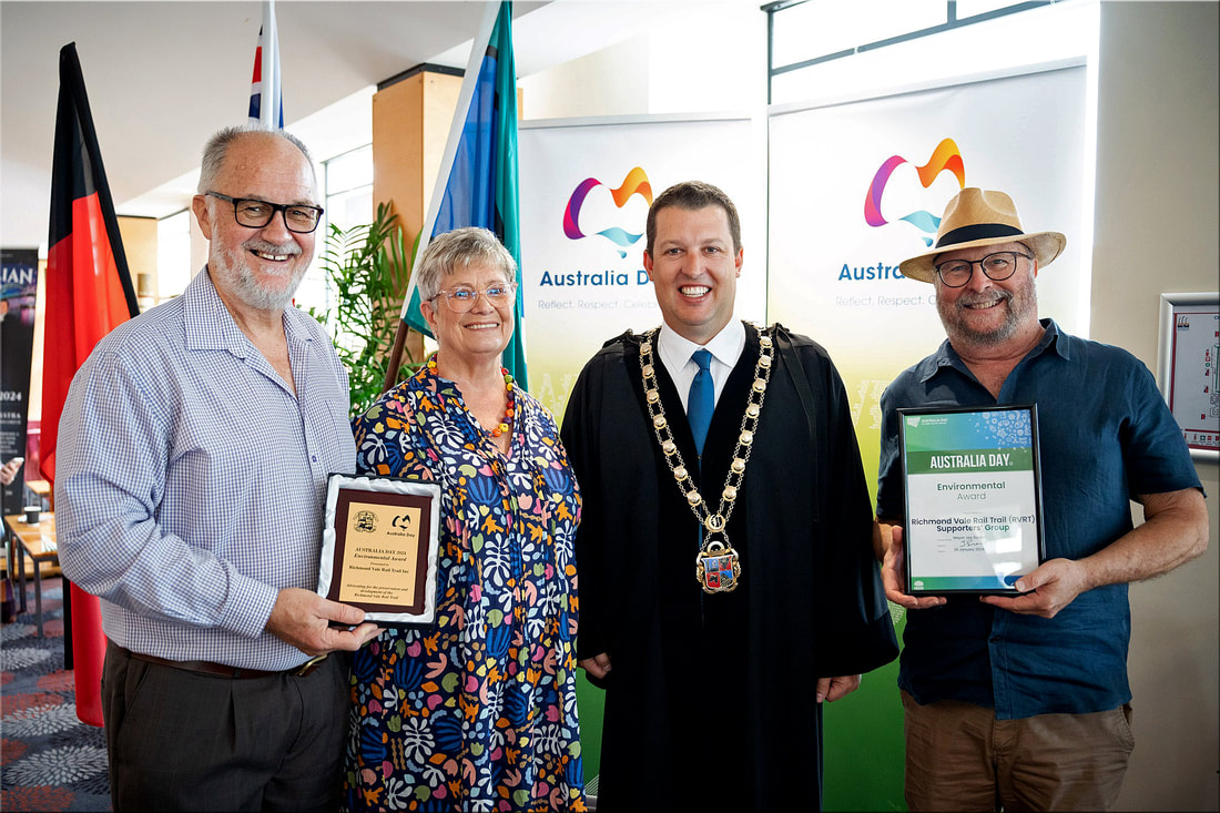
Thanks to our RVRT Supporters’ Group Committee, Members and Supporters
0 Comments
|
News Archive
|
||||||||

 RSS Feed